The Cold Hill

7.75 miles 498m ascent 3h 46m

Descriptions of this walk on the net include such comments as “Beware! Much of the ground on this route is horrific- tussock grass, boggy, rocky and felled forest areas. Its hard work” and “the going here is tough – wet, with deep heather and much tussocky ground.” As I found reading after the walk.

I had intended doing the quick route up Hart Fell today but the forecast said the cloud base would be at 700m and I didn’t fancy another walk in the mist. Delightful and soothing it may be, but the views and photo opportunities are somewhat reduced.

So where to go? As chance would have it, LOML was reading her magazines and said there was an article about Millfore. I had a glance and my mind was made up. Millfore it would be, another Donald to add to the list.

I parked by the Black Loch and though dry it was bitterly cold. So cold in fact that I kept my hat, gloves and coat on for the entire walk, which is unusual for me, since I’m not fully exertion-enabled and quickly heat up. Since it was a solo walk I decided to take my new hat, which has a bobble on top and presumably makes me look like Noddy. (Message to self – remember not to wear hat with red fleece and blue shorts.)

I decided as well to take my anvil-weighted bigger camera out as well to see if the pictures were any better. I don’t think they are but the camera added to my experience by twice bumping up into my face while I was climbing down some steep sections. This made me bite my tongue on one occasion and cut my lip on another. Damn camera must be cursed.

Anyway, with said camera I was able to take some more shots of the Eye at the end of Black Loch, though the light was rubbish and the shots are not much better than the last visit when it was overcast.

The forest track winds around the end of the Loch and climbs steadily. I took this as a good omen. The more climbing on nice tracks, the less on gallovidian terrain. Since there is no all encompassing adjective to capture wet, boggy, pathless, deep heather and tussock covered, I will in future use the term “gallovidian”. As it was, about half the walk was forestry and the other half gallovidian.

My first glimpse of Millfore was from the forestry track just after I passed beneath some electricity pylons. It looked grim and seemed to have steep rock strewn sides. Then as the track wound on Millfore’s summit dropped below a smaller hill, Kirkloch, and I forgot about the rocks.

There is a ridge running down SSE from Millfore and the I joined it it where the track runs near Poultrybuie Hill.
I left the track for gallovidian ground following a rather faint path and just to highlight the difference, within 20 paces of leaving the forestry track my right foot sank beneath the tussocks into ankle deep water. I managed to do the same at the same spot on the way down as well.

The path did not last long and then it was tussocks, heather and hidden pools as I made my way up. There were several very steep climbs, some up heather, others up rocks and my main hope was that on the way down I would spot a better way or even a path.

I came then to a barbed wire fence, much rusted and in disrepair. One area was trampled down by, I presumed, the passage of many walkers, so I used the gap, and followed the fence a while since it had tussock free ground near it. This led me a little to the east but took me away from the crags facing south. Eventually I spotted a cairn, and then another. These marked Kirkloch which is at about 400m. It had taken an hour to get here.

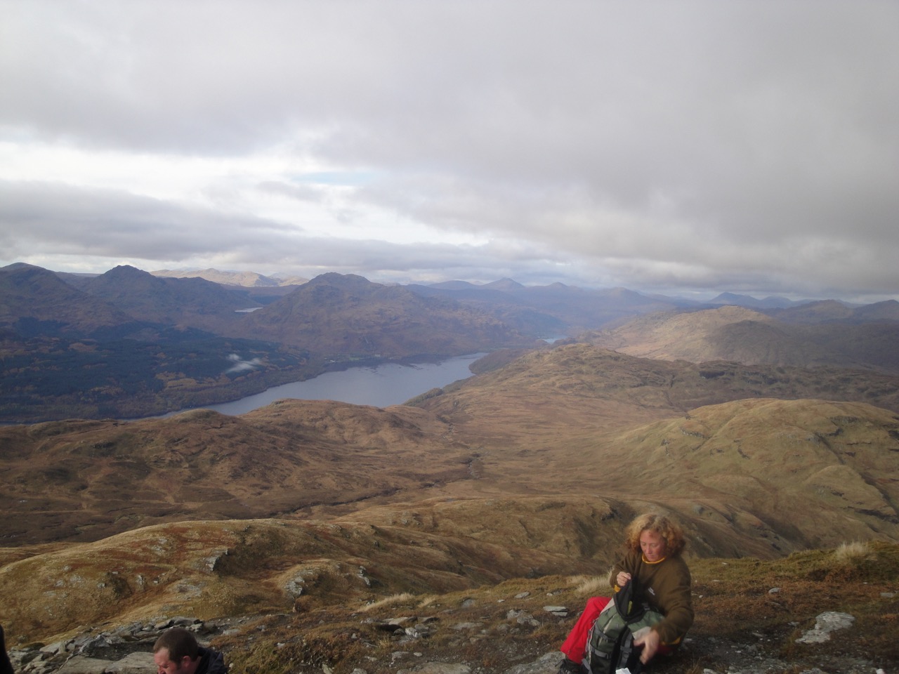
The views from Kirkloch were surprisingly extensive, with Cairnsmore of Fleet, Wigtown Bay, and even Criffel visible. To the east were Craignell and Darnaw as well as the dark lump of Black Craig of Dee.

From Kirkloch the ridge leading up to Millfire and a further 250m climb lay before me. There is a picture taken in summertime on the geograph site that says “this grassy ridge provides a very straightforward route to the summit”. It may look grassy but it isn’t. There was more gallovidian terrain and even a brief spot of scrambling.

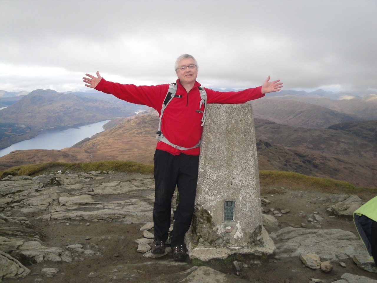
As I climbed the last few metres to the top of Millfore I realised that the strange sensation on my face was snow. I was able to get some photos of Loch Dee and the White Lochan of Drigmorn but then the cloud started to fall, as did the temperature and much more snow. I had just finished messing about with the camera’s timer to get a photo of YT when the weather turned much worse very quickly and I decided that bottling it was the appropriate response. I stuffed the camera in my bag and headed down quickly, going eastwards to avoid the crags I had recently climbed.

Millfore means cold hill (Meall Fuar), and it certainly was. And I have to mention the White Lochan of Drigmorn again. Apparently this was a favourite spot for curling in bygone days. I take my hat off to those who would toil all the way up there to curl. I used to moan about driving to Lockerbie for curling. I presume they chose stones when they got up there rather than carting stones up with them.

My hopes of finding a more obvious path down were not to be fulfilled. The easier descents always led off towards Munwhul. That would be an extra mile or more on forest track, but I was wary that the ground might turn out to be just as bad so I stuck to returning the way I had come.

Once the forestry track was in view my spirits lifted and perhaps that’s why I wasn’t paying enough attention to prevent me dunking my foot again.

Once back on the track the rest of the walk was a breeze, mostly downhill. in fact on the way up I felt it was all uphill, but going back down there were some uphill sections. There is a shortcut from above the Black Loch which avoids walking all the way around the loch but requires fording the Tonderghie burn. I thought a fall in the burn would spoil the day so chose the longer route. The eye was better lit in the evening sun so more photos were required.

The rain didn’t start to fall until I was in the car.

Donald count = 1
Wet foot count = 1
Bitten tongue count = 1
Feeling of achievement = hell yeah

PS despite driving along the Queensway several times I had not noticed the old heather covered bridge next to the modern road bridge (see gallery). The Black Water of Dee looked black, as did the Black Loch for that matter, and from up on the hills Cairnsmore of Dee lived up to its alternate name of Black Craig of Dee. I got on photo where it just looks like a black lump, but by the time I climbed higher for a better picture, it was lost in cloud.

Posted in Dumfries & Galloway | Tagged , | Comments Off on The Cold Hill

Splashing in Mabie

5.8 miles 1h 45m 284m

An uneventful walk under the traditional grey skies of D&G, wet underfoot but not on the head, snow topped hills in the distance, avec les chiens. One of the latter snuggled up against me just now.

Well, its been a while since we walked Mabie’s flat paths and I for one had forgotten that Craigbill Hill is actually a hill.

The MTB riders were out in force though we only saw them on the larger, flatter, paths. Our own route took us past the old stables, then the ghost stane and onto the phoenix trail which after several windings led us back to the brown walking route. Then it was a gradual climb, overtaking a woman and her terrier towards Craigbill Hill. Looking north from this path the windfarm at Dalswinton could be seen bathed in sunlight.

The viewpoint a Craigbill was an excuse to take a breather. Criffel was topped with cloud, Knockendoch standing before it cloud-free. Changing the viewpoint from distant to near there was a noticeable difference in below-knee spatter between myself and Andrew or Elaine suggesting that we have different gait patterns. Perhaps I tread more carefully and quietly having grown up in a house with a father working nights?

Looking across Lochaber Loch, Bishop Forest Hill was topped in snow though it is only 100m higher than Mabie.

For once our walk along the path towards Dalshinnie Glen was in the downwards direction. I still remember trudging up this section with the wind and rain in my face last year – character building. Much better descending than climbing. (The last sentence has been edited because the original was open to misinterpretation.) There seems to be a new raised walkway around Dalshinnie Loch, but we have left that for another day. I do feel uneasy about calling Dalshinnie loch a loch, pond would seem more apppropriate.

Here we began another minor climb past the lunatic section of the MTB areas and up towards the Wigwams. These look to be in use at present with smoke coming from their chimneys. Then from Marthrown it was all downhill, the sunlit Solway visible and Mabie in its best Autumn colours.

Our only strange sight was a rather diminutive dog carrying a stick that was almost as large as it. (see gallery). Coffee was taken next to a warming fire and no mention made of the next outing.

So that is one week without anyone falling, getting lost or finding an impassable path. I suppose I did drop my camera in the mud but I don’t think anyone noticed.

PS both dogs are sleeping soundly, one snoring (takes after his mistress).

Posted in Dumfries & Galloway | Tagged , , | Comments Off on Splashing in Mabie

Lost in Almorness

8.3 miles 3h 10m Ascent 295m

Mike’s evil twin, the one who takes over his body and mind when choosing routes, surpassed himself with this easy, flat stroll in the solway riviera.

A short walk, on OS paths, so no need to take the map. We left the car in Palnackie, which is world famous for its flounder tramping, and headed south on the west side of Urr Water past the North Glen Glassworks. The road then passes through Tornat Woods and we left the the main track to head over fields. The height gave good views of Glen Isle, Rockcliffe and Rough Island.

Unfortunately the path petered out and we crossed a stile to climb a little higher and having negotiated an electric fence followed some vehicle tracks. I had thought that we had strayed off the path but looking at the aerial photos in bing maps we were actually very close to the true route.

The vehicle tracks led us, through slightly boggy ground to the upper corner of a field with a drystone wall and electric fence. The fence had a stile next to steps in the wall. Although the nearby shrubs and trees had almost overgrown the area it seemed the most obvious way to go. The actual route was out from the bottom corner of the same field.

Our new route allowed us to practice our quagmire crossing skills, something you don’t get to do on namby-pamby paths. We’ll all laugh about this one day, I’m sure.

So eventually we were back on a track, having reached the road to Almorness House just a little south of Orchardton Tower. The path has some rather imposing gateposts and a new looking drystone wall.

From Almorness House there were several paths to choose from. One was clearly the path we should have arrived on, another the path we would expect to return along. That left two more. One heads down towards Rough Firth and we took the less defined track leaving the first via a farm gate. This is indeed the correct way.

We came to a fork in the path and took the right hand fork which climbed to higher ground. Though this eventually led us back to the path is was only after fighting our way through a dense bramble patch because the path was flooded. The first time in D&G that I have felt the need for a machete. I bet Jo would have had one in her rucksack.

A bit of a diversion but we were back on the real path…for a while. The next diversion came near to a pheasant coup. We had climbed a small promontory, marked as “52” on the OS and could see across to another small hill which is the Moyl, the hill at the end of the peninsula.

Having returned to the coup we headed off along a faint track and in so doing left the real track, though for the life of me I couldn’t see it. The new path headed south, rather than south east. Instead of leading us to the beach of Horse Isles Bay we were about 250m west of it in an area marked as “Merse” and characterised by tussocks, mud, standing water and eventually a small lochan spilling out across our path.

Following an unsuccessful attempt to head west…more water, time was called. I hadn’t got the part of the message about the need to be back by 2pm and was therefore unaware of the growing frustration with our lack of progress. So back through the quagmire it was.

We were about 350m from Almorness Point, when we turned back but I’m not sure the way was passable where we were.

The walk back took us past Orchardton Tower. This was built in about 1456. There appears to be a shed on its roof, but googling reveals this to be a gabled caphouse covering the stairwell.

Refreshments were taken at the Glenisle Inn.

Though, obviously, we will need to lick our wounds and recover psychologically from this trek, one day we must return, perhaps in wellies and with machetes in hand.

PS Some information on Beeswing

Posted in Dumfries & Galloway | Tagged , | Comments Off on Lost in Almorness

Ben Lomond and Scotch Mist

View from below Ben Lomond7.6 miles 974m ascent 5h 4m

Fortified with the full Scottish Breakfast we set off on our Halloween walk. The weather looked clear but as we drove along Loch Lomond low cloud gradually became low lying mist.

It was in a dusting of mist that our trek began from the car park at Rowardennan. Five minutes on the flat then a right turn to begin a slow climb. Apparently there is a swimming pool thereabouts but I didn’t see it. It took about half an hour to climb out of the mist and you’ll see from the photo gallery that the exertion had warmed us up nicely, with perspiration and glistening (depending on gender) for all concerned.

Even at these early and low level stages there were fine sunlit views of the mist covered loch and the Cobbler with its surrounding hills. The higher we climbed the more impressive the views became. The path was narrow but in good repair, clear and free of the mudbaths we see closer to home.

We made our way past a rocky outcrop which the OS has marked as Tom Fithich. An interesting name since this is where we first spotted a large black bird with a croaking call. The bird seemed to follow us all the way to Ptarmigan and at times came close enough for us to get a good look at it. Having trawled the internet, looked at pictures and listened to the sounds of various birds, I’m convinced this was a raven. Then when I looked up “Tom Fithich” I found it is gaelic for Raven Knoll. Is that weird or what?

From the Raven Knoll, Ptarmigan itself is visible with the path meandering up towards it and becoming a little steeper. I think I had perfected the mcmahon trudge on this section. Steady yet slow enough to avoid the need for many pauses. I don’t actually have much trouble going slowly, it’s more about overcoming the psychological need to keep up with those ahead and not worry about slowing down those behind. Once on Ptarmigan we posed for pictures, rehydrated then set off along the ridge to Ben Lomond. From Ptarmigan the hills to the north were visible and seemed to stretch into the distance for ever. The photos don’t do the views justice.

Ptarmigan didn’t have any visible ptarmigans on it. The Pt part of the name is apparently a misspelling introduced 400 years ago, the gaelic name for the bird being tarmachan.

The path from Ptarmigan crosses the Bealach Buidhe (the yellow pass) and leads to some rocky steps and then a short scramble to the summit of Ben Lomond. It was a satisfying achievement and we had some extensive views until the cloud started to darken and spread. The climb had taken us about 3 hours. The packed lunches were welcome by this time and the sandwiches proved to be more manageable (in other words, I was able to eat the whole thing.) It did feel much colder despite adding extra layers and I suspect the weather had begun to turn.

Ben Lomond summit

Ben Lomond summit

Heading down, the rain kept threatening, with the odd droplet arriving now and again. Enough to keep the jackets on and cause a little overheating. After the excitement of the climb our downward trek seemed a bit of an anticlimax and did seem to drag on a bit, but perhaps that was tiredness creeping in. We had seen a steam train the day before and this walk was graced by sight of a seaplane taking off from the Loch.

The car was a welcome sight when we got back down. But, alas, the toilets were shut so we were forced to stop at a pub (for coffee and tea).

A great walk. Good choice, David. I’m not sure how we can follow that. Our local walks will seem either a little less exciting or a great deal muddier.


Posted in Far away | Tagged | Comments Off on Ben Lomond and Scotch Mist

The Cobbler

7.53 miles 919m ascent 4h 39m

The weather on the way up to to Beinglas was dreadful with plenty of standing water on the roads. Each time we drove through one of these monster puddles the windscreen was drenched like a ride on a log flume. Not a good omen for a weekend’s walking.

having arrived at Beinglas Farm we found the road completely under fast flowing water, but intrepid Joanna (4WD off-road experience) got us across. Car #2 was given directions for the back road, an adventure in itself.

After all that we needed rehydration and calories. The food was very good, though the Beinglas belly-buster burger beat both David and myself into submission. No room for sweets.

Excellent rooms, so after a good sleep and full scottish breakfast we were good to go the next morning. The weather had improved. The flooding had receeded but the clouds were still low. David had several alternative walks so we decided to head for the car park at the Cobbler and decide there if it was to be hill or low level walk. Luckily the cloud decided to lift.

Having parked at the top of Loch Long we crossed the road and headed up the path. Zig-zagging up the first hundred metres warmed us up. As we climbed higher and came above the trees the views improved. Ben Lomond was visible above Arrochar and we could see down Loch Long to the Royal Navy munitions depot. Loch Long is gaelic for ship lake, and Arrochar to Tarbet is where the Vikings took their longships overland to raid the shores of Loch Lomond.

I had a minor upset having stopped to doff my fleece and finding I no longer had my camera. Last held 100m back down the hill. I searched my pockets and my bag, but no camera. With a sigh I asked Joanna to mind my rucksack while I walked back down and moved the rucksack off the path. And there was the camera, on the floor under the rucksack.

The path is steep, but once the small dam on the Buttermilk Burn is reached the gradient eases considerably and we got our first good views of the Cobbler. Initially there was a dusting of cloud on the summit lending it a rather brooding appearance but as we climbed further the cloud base lifted and the hill was bathed in sunlight. With the autumn colours of the bracken and sunlit grey of the rocks a camera’s delight.

David forged ahead and was waiting for us at the Nanairn boulders, something to do with the need for privacy. From here we left the main path to cross the burn and head up into the rocks for a spot of scrambling. I find that my mind confuses that word with scrabbling and I feel my rather slow progress up the rocks needs another description. (Straggling?)

I certainly feel achievement after straggling up rocks, even if it is only the mountaineering equivalent of swimming a breadth in the shallow end. The rocky path then led us up to the north peak, and spectacular views of the Arrochar alps, Lochs Long, Lomond, and Ben Lomond. We even had a glimpse of the steam train on the West Highland Railway.

Lunch was on the North peak. The packed lunches from Beinglas were well named. My sandwich was so packed that I couldn’t finish it. My loss, Oscar’s gain.

Time for a choice. Back down, centre peak or Beinn Nanairn? Down we went and then up to the true summit to peer through the eye. That done we decided to head off the hill. The path down the back of the hill was a gentle stroll for the most part, with views of Beinn Ime, the Beinn Nanairn and for the later part Ben Lomond.

As we neared the Nanairn Boulders again Oscar did what all dogs must do. He jumped into a muddy pool, and then ran over to us to shake himself dry.

I hadn’t realised how steep the lower path was until we were going back down, but down is sooo much easier than up. It was a joy to see some youngsters trudging slowly up as we flew down.

After a brief stop at a pottery to admire the salt pigs we headed back to base only to find the A82 closed due to a car accident. This forced us to take refreshment at the Tarbet Hotel until the road opened.

A great walk in unexpectedly good walking weather with the right mix of walking, straggling (scrambling), views and coffee. Good choice David.


Download file for GPS


Posted in Far away | Tagged | Comments Off on The Cobbler

Walking in the Dark

0.2 miles 5 hours

A walk unlike our usual hikes. We assembled at an unusual meeting place, the cafe of DGone, where we found David babysitting a young lady from Finland. Elaine and Lynn, bedecked in dancescottishforpudsey.org were spirited into the inner sanctum to look after the injured bear. So we three guys were left to make lady Finn feel welcome (I didn’t catch her name) while watching for Pudsey to walk past. While waiting we met various people, David’s in-laws dropped by, and a woman who told us she had a group of two year olds dancing and they were frightened of bears. She introduced herself by looking at me and saying in a rather accusatory tone “I know you”. Well she does (non-biblically), and “hello” would have been more appropriate. And how the hell do you teach scottish country dancing to two year olds. Won’t they keep falling over? David got it right when he said it would be like trying to herd cats. They looked older than two years old to me.

Eventually the cafe began to empty with shouts suggesting Pudsey was outside. He had sneaked by without us noticing. Turns out he used a back door. Obviously he has some experience of this showbiz stuff. Anyway that was our cue to go backstage. Oh the joy of flashing a backstage pass.

We found our room, slipped into our gear and waited for Pudsey to return. He had certainly warmed up quite a bit and we needed to play the fan upon his head several times throughout the afternoon to cool him down. He warmed up very quickly once on stage and he was a little clumsy, presumably because the loss of binocular vision impaired his visio-spatial sense. I understand now why he needs his helpers to guide him about. He also has syndactyly with only three fingers on each hand, which made me feel quite unexpectedly uncomfortable.

Happily no outsiders were there to see David’s medley of dirty dancing moves. They brought tears (of laughter) to my eyes but I thought video would have been inappropriate. I regret that decision now.

It was strange that Pudsey varied quite a bit in his dancing ability at different times. I can only presume he liked some music more than others. I had hoped we could have had a picture with all of us with Pudsey, but there always seemed to be one of our party missing. One very curious thing was that whenever Andy was missing, Pudsey walked like Huggy Bear from Starsky and Hutch. Strange.

We weren’t allowed to feed Pudsey during his appearance, but I felt sorry for him even though he did seem a bit portly. I left some snacks lying about in the back room and some did disappear. I’m pleased he didn’t need to use the toilet. I don’t know much about bears but I do know that they have to s**t in the woods. God knows how we would have got him out to Mabie.

The dancers costumes were very good, at least those I saw. More than £1500 was raised so I heard.

I look forward to the youtube videos. You can see some more pictures of Pudsey below.

Posted in Dumfries & Galloway | Comments Off on Walking in the Dark

The Rhinns of Hell

15.9 miles 1332m ascent 8h 40m

Well, what can I say? We met, fed, bursting with energy, wagging tails (those that had them), and ready for a day forecast with sunshine, to feast our eyes on the views from the Rhinns of Kells.

Three options faced us, circular from Forrest Lodge or linear from Forrest to the Green Well of Scotland. Well, horseshoe rather than linear but topologically speaking it’s the same thing.

On the drive out to Carsphairn we spotted plenty of birds of prey, many grouse and even a red squirrel, but the hills were to prove less well stocked. No goats on Meikle Lump for example, despite others reporting them always present.

So, having dropped off one car on the old road at Bridgend, we crowded into Joanna’s car and set off for Forrest Lodge, driving past the Energy building with a turfed roof. The sign at the parking area warned there was No Parking after 8 pm. But what was that to us at 9.30 am?

I had chosen this nice easy walk to break in my new boots for the halloween outing.

The roads in the estate are all named after Olsens or people I presume connected to them, and we set off along Prof. Hans Heiberg Road. I’m not entirely sure who the professor was. There are several Hans Heibergs, but the most likely I think is Hans Herman Hjortdahl Heiberg (1904-2000) a Norwegian forester and botanist.

The Fred. Olsen company, which began as a shipping concern also now has interests in renewable energy which might explain the turf roofed building. More on the history of Fred Olsen.

As I mentioned we set off along the eponymous track, overtaken at one point by a farmer on a quad bike with a spaniel sitting behind him. The path has a gentle rise at first but then rising to a level sufficient to warm the muscles. Oscar was exploring the woods but returned after something made him yelp. Probably a sting from a wild haggis.

A little way after Kristin Olsen Road we passed a green observation tower which looked as if it ought to be guarding some far off frontier, perhaps that between Galloway and civilisation. And a little beyond this there is a post marking the path to Meikle Lump. Now path it may be, defined as a stretch of ground that is not completely impassable, but it was very boggy and at one point blocked by a fallen tree. It led us to a stile and gate and the hills proper. Here the gradient increased significantly to red face level.

The last time I came along here I turned left and walked to the wall which I then followed up Meikle Lump and Millyea, But it had been very wet so I recommended an oblique direction to the wall. Unfortunately I was defeated by tussocks (may they rot) and went the boggy way instead.

Three things differed in this ascent compared to my last. I was with company which added a certain esprit de corps and buoyed me along a little faster. The weather was worse, though not terrible, it was dry but the cloud was low and we soon climbed into low visibility. But thirdly, it was a damn sight steeper this time.

By the time we reached Meikle Millyea and its sneaky summit 300m from the trig pillar, we were in cloud. I’ve put some of the photos from the last walk on a separate page so you can compare views from the same place.

Unfortunately the extensive views the Rhinns afford were denied to us and this changed the walk from the sight-seeing expedition I had hoped it would be, to more a heads down route march up and down a bunch of hills, all looking much as the last did.

We followed a tumbled down dyke from Meikle Millyea (Meikle=large (scots), Meall Liath =grey hill (gaelic)) over Milldown (brown hill) and onto to Millfire (wooded hill, or hill of ravens). Up on the ridge the wind had picked up considerably, though not to a level where it impeded our progress. I was pleased to find that my hood offered good protection to my cheeks. I had previously stopped on Millfire for lunch but the small cairn didn’t offer enough shelter for five. We sat down behind a small hillock, which took the edge off the wind and ate with little conversation. My coffee was the cool side of luke warm, which just about summed up my spirits too. Some of the views in better weather, from Millfire are on the photo page.

There is a descent of about 90m from Millfire to the col between it and Corserine, which was a easy descent with improving visibility as we came out of the clouds. There are some cairns here marking the point where the old shepherd’s track crosses over the Rhinns of Kells.

The 190m up to Corserine does not look particularly steep on the map, nor to the naked eye, but it certainly feels steep. The summit of Corserine, unfortunately was in cloud. No panoramic views and no visible points for navigation either.

Then it went pear shaped.

We could see the trig point on Corserine but only because we were standing next to it. Map, compass and discussion gave us our direction, and looking at the GPS track we did set off in the correct direction but gradually turned to the left without realising it. Consulting the magic device we were given a grid reference that seemed so unlikely that we dismissed it as incorrect, which in retrospect was a mistake.

When we reached the downhill section I didn’t recognise it. There was scree rather than rock and grass. The scree looked too dangerous so we headed back up and came across a faint path to follow. I do recall crossing a more defined track, which must have been that from Corserine to Carlin’s Cairn. We seemed to be following a ridge but were in fact contouring onto Meikle Craigtarson.

Eventually we descended far enough to come out of cloud and were faced by a descent onto a minor hill with a forest track at its edge and a large hill to our right, apparently running north with a loch visible in the distance. The bad news gradually sank in. We were 200m down the NW face of Corserine below the Fallincherrie Scar just above Meikle Craigtarson.

It looked like a long climb back up. It felt like a long climb. But the tussocks were not too bad and 20-30 minutes had us on the col between Carlin’s Cairn and Corserine. We had spent about an extra 75 minutes on the detour.

So we were faced with climbing back up Corserine and heading back to Forrest Lodge or pressing on to the second car at the Green Well. The latter was slightly longer but avoided the steep climb down Craigrine which I didn’t fancy doing in low visibility having already gone wrong once before.

We had done three Donalds so far, so on we went for another three. The climb to Carlin’s Cairn seemed relatively easy compared with what had gone before, but yet again we were back in cloud.

From a distance both Meaul and Cairnsgarroch look like minor humps on the ridge, and they don’t jump out as tall hills from the OS map. But up close they are impressive with some very steep sides. Both easily over-reach Criffel.

The 200m drop from Carlin’s Cairn took us back out of cloud and by the time we had climbed Meall we were in sunshine. And this wasn’t just any sunshine, it was the golden light seen in the last hour of daylight.

From Meaul we could look north to the mighty hulks of the Rhinns of Kells, still topped with cloud, and south to Bow and Coran of Portmark bathed in golden light. A wall heads down from Meaul and over Cairnsgarroch with an accompanying fence to climb along the way. A navigational aid when we didn’t need one.

Cairnsgarroch was a place for another breather. It was the last summit but not the last hurdle. Heading down was initially slightly tussocky but we made good progress. The end was in sight, but still quite far away. I worried that the last few metres would have to be steep because we were still quite high up.

Steep it was, and the tussocks were larger, but with zig-zags my knees just whimpered rather than screamed. My left ankle though was burning. David, as ever, exhibited his disdain for the terrain by forging on at an inhumanly fast speed.

He appeared to be making for a gate to the SE of Craighit. As I approached it I was thinking that a gate meant a track and a gate that big meant a vehicle track. Sadly the gate was an optical illusion made by the junction of three fences. No track there but we made for one one winding around the north of Craighit.

We followed the quad track through wet grassland until it led us to the footbridge as marked on the OS map. The bridge was an ex-bridge. All that remained was a single rusting spar. From a distance it looked as if this might be crossable while holding onto nearby trees, but close up this was obviously not possible.

Further along the burn looked to be fordable but we decided to look for a better crossing. David managed to cross on a metal pipe using walking poles as stabilisers. I knew I would not manage that. We all eventually got across on stepping stones. Then we were just seconds away from the path which increased in quality as we followed it.

The path was like water for a thirsty man. Ahead were the Carsphairn Hills and to either side wet grasslands bathed in evening light. We crossed Carphairn lane on a stone bridge, then over the Water of Deugh on the A713 and back to the car at last.

We were back at Forrest Lodge well before the 8pm deadline.

A challenging walk in poor visibility. The pathless sections coming off Cairnsgarroch were unpleasant but the ridge itself is easy walking. It was a shame we were denied the scenery.

6 Donalds (including one Corbett) and one Donald Top in a day.

Posted in Dumfries & Galloway | Tagged , | Comments Off on The Rhinns of Hell

Foot and Ankle 5K

Not a walk, but my first fun run. 5K around the roads and woods of Yorkshire.

My intention had been to walk the course, but that proved impossible since it was not a well defined route so I had to jog with the crowd to know where to go.

Rather worryingly we began by running downhill for 10 minutes. We climbed over walls, through fences, ran along forest tracks, muddy and rocky, then got lost in a park but I didn’t have much spare concentration to admire my surroundings. I reckoned every 5 minutes was one eighth of the run done and spent too much time concentrating on my watch.

You might wonder how I got lost when in a group who know the area? Well after 20 minutes the group paused for the stragglers (#1 and #6 in picture above) to catch up. Even as we approached the waiting athletes, us still jogging, it was clear to me that a discussion had taken place, and there were now two groups, them and us.

We were to split into the 5K and the serious runners. The 5K team (#1 and #6) were given directions, which I must say were accurate but incomplete. Luckily a passing local sent us in the right direction.

Well, I suppose it’s an achievement, but why will it be my last run? Let W H Davies speak for me.

What is this life if, full of care,
We have no time to stand and stare.
No time to stand beneath the boughs
And stare as long as sheep or cows.
No time to see, when woods we pass,
Where squirrels hide their nuts in grass.
No time to see, in broad daylight,
Streams full of stars, like skies at night.
No time to turn at Beauty’s glance,
And watch her feet, how they can dance.
No time to wait till her mouth can
Enrich that smile her eyes began.
A poor life this if, full of care,
We have no time to stand and stare.

Walking gives more time for this sort of thing.

As a Lancashire lad, it pains me to say it, but Yorkshire did look quite nice.

Posted in Far away | Tagged | Comments Off on Foot and Ankle 5K