
7.33 miles 4h 26m ascent 245m
Berwick-Burnmouth
There is an attraction in these billowy uplands
which increases the better we know them; beauty
in the mighty stretches of green pasture sloping
upwards and backwards, as often as not vanishing
into grey mist in the acres of waving brake, the
many-coloured rocks and boulders, the flashing
streams and burns, the flowers and wild birds, less
wild here than in the peopled lowlands. Then there
is the silence and all-aloneness of the Borderlands. You
may walk all day and see no one except some solitary
fisher, or a shepherd and his collies on the fellside;
above all, perhaps, there is the consciousness that
you are treading on historic ground, where each hill
could tell of some fierce conflict, and where each
valley and stream is associated with the loves, the
passions, and the death-throes of buried races.
— John Cordeaux.
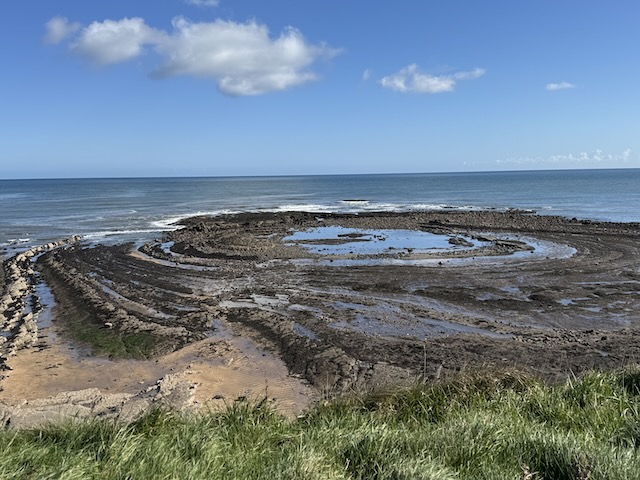
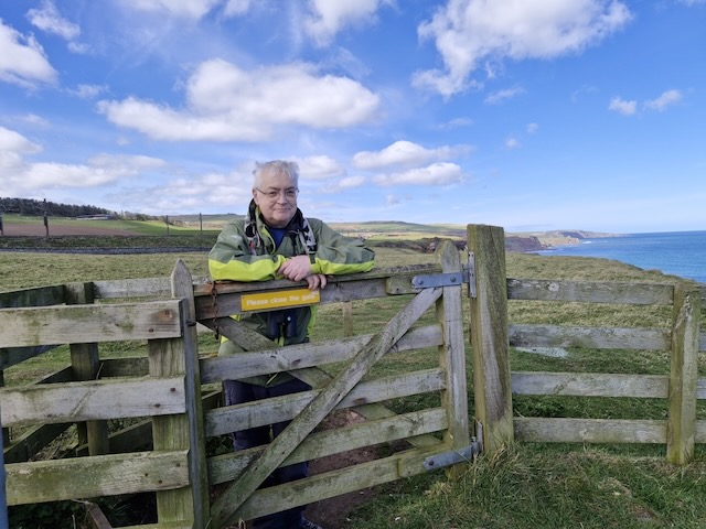
Our taxi dropped us by the Lowry Shelter in Berwick. We had our photos taken then headed back on to the England Coast Path and short climb to where we could look down onto the curves of Bucket Rocks and the swirl of Ladies Skerr. (I find the lack of an apostrophe here grates somewhat so L et’s put that right: Roll on, thou deep and dark blue Ocean – roll!)
Here we were on Magdalene Fields. I wondered if there had been an abbey here and was not far from the mark. It was the site of a religious hospital in medieval times. Now there is a golf course, a holiday park and fields with lambs and sheep. What would the penitents would make of that?
The Berwick ramparts were off to our left with the Lion House standing proud behind them. A small coastguard tower looks out over Fisherman’s Bay and the Skerr. A good place to marvel at the rock formations. The OS map shows a Covered Way between the cliff top and ramparts but any covering is long gone. Now it is just a mown path in a hollow. [PS I wonder if it was covered, as in not-in-line-of-sight, or even watched-over.]
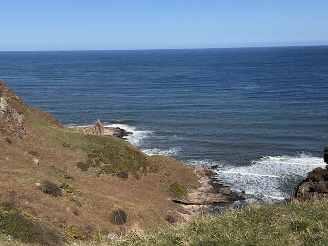
We skirted the caravan park walking along the cliff-tops and around a small burn marked as Dodd’s Well. I am not sure if this bay has a name. A geological website calls it Murphy’s Bay. On the southern side of the bay there looked to be graffiti covered alcoves carved into the rock. Older OS maps mark the area as “Rifle Range” so the alcoves might date from that time
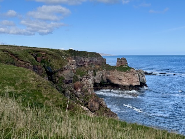
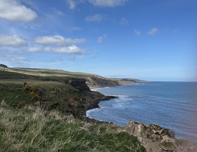
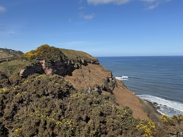
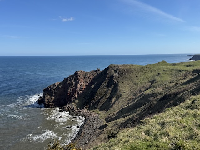
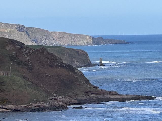
The vast majority of the days walk would be along the strip of land between the railway and cliff-edge. Once away from the bustle of Berwick our soundtrack became the gentle breath of waves lapping the skerry far below, interrupted now and then by the call of a gull or the soft purr of an electric trains. There was not much to see, other than railway, when looking inland but the soft purring of electric trains. So our attention focussed on the slim strip of land ahead, the cliffs, and the sea. Our taxi driver said he often saw porpoises so I kept an eye out for them— I didn’t see any. The cliffs were much steeper than those south of Berwick and looked to be actively eroding—some old sections of wall had obviously taken a tumble—so we always stayed well clear of the edge. Since the coastline weaved round a great many small coves we were able to have some good views of the the cliffs, caves and tidal rock formations. A couple of more the prominent rocks are named: The Needles Eye and Maiden Rock.
They sing of the grandeur of cliffs inland,
But the cliffs of the ocean are truly grand;
And I long to wander and dream and doubt
Where the cliffs by the ocean run out and out.
—Henry Lawson. The Cliffs, 1903
There were plenty of coastal birds, both on the water, and nesting in the rocks. I’m not particularly good at identifying birds and usually congratulate myself on showing a level of ornithological sophistication by referring to seagulls as gulls. We did hear a few skylarks along the way, pied wagtails did what it says on the tin, and a wee fellow that we reckon was a reed bunting hopped along the fence ahead of us; but in the main we saw cliff nesting birds. No sign of the peregrine falcons mentioned on a sign we passed but plenty of guillemots huddling on the cliffs,j especially on the more isolated stacks. And a shag that at first I had thought was a cormorant—but I had the binos and got a good look. Plenty of gulls, I can only be certain they were not herring gulls. They had black bars near the tips of otherwise grey wings. Best guess: common gull. And one very beefy gull that looked as though he had been working out. Unfortunately my misspent youth as a plane spotter has twisted my ability to identify flying things: number of engines (not usually much help in bird ID); shape of tail (useful for red kites); position of vertical stabiliser (useless in birds); shape of nose (possibly useful).
When we could see a caravan park ahead we knew we were coming to Marshall Meadows. This is the most northerly part of England; further north even than Arran. The bay has beautiful sheer cliffs rising 50 metres above the sea. It looks like the kind of place one could hide a tall ship.
When the shore is reached, the traveller will find
himself in one of the most remarkable bays of the sea
to be found at. any part of our coasts. A great amphi-
theatre surrounds him, bounded on the landward side
by a semicircular vertical precipice at least one hundred
feet in height. The beach is strewn with huge boulders,
and as at high water the sea laps the base of the cliffs,
if an attempt to reach the Border Wall by this route is
made, the state of the tide must be carefully considered.
A walk round, or a climb over the slippery water-worn
rocks will bring him to the north point of the bay, after
which he will stumble along with risk of a broken limb
to reach the wall. Having accomplished this
feat, he may seat himself thereon, and for the time being,
claim the double distinction of occupying the most
northerly point of England, and having reached the
eastern terminus of the Border Line.
— from The Border Line. James Logan Mack, 1926
The border between England and Scotland has ebbed and flowed. England once ended at the Humber but eventually stretched to Edinburgh. The Tweed would be the frontier for centuries but Berwick changed hands more than a dozen times until it became English with the Treaty of Fotheringhay in 1482. But even then Berwick was something of an outpost: described as “of England but not in England” in the Treaty of Everlasting Peace (1502). If any doubt remained it was quashed in the Berwick and Wales Act of 1746, which made it clear that any mention of England included Berwick. So all that stuff about Berwick still being at war with Russia —Crimean War—is just a tall tale.
I haven’t been able to find an explanation of why Marshall Meadows was chosen as the place to set the border that remains at the Tweed until a little short of where it is joined by the Whiteadder. My best guess is that the treaty used the Bounds of Berwick as the border line. What we would call Marches (as in riding of the) are called Bounds in Berwick.
We knew The Border was close when we passed the bay and were looking for a marker of some kind. So when we came to some chequerboard symbols painted on the ground we thought we had found it. While we were posing for our crossing-the-border photos a woman walked by and casually remarked that we would soon be at the border. She was correct. The actual border was at a kissing gate a few metres further north. Older photos show a Failté gu Alba sign here but now all that remains of that sign are its uprights.
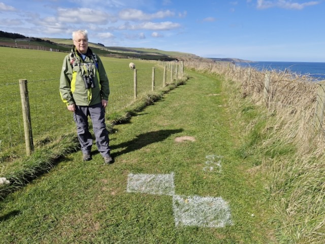
Are we not welcoming anymore? Or perhaps our welcomes are so fulsome now that words are unnecessary. We took our border photos proper.
A wooden sign placed to greet those heading south reads ENGLISH BORDER CUDDY TRAIL. I thought I had taken a photo of it but either I didn’t press the button properly or some malign power has deleted it from my devices. This was the first I had heard of the Cuddy Trail.
A little further on was a faded information board, for The Cuddy Trail.
In history there were several coal pits on the shore and in the cliffs. The cliffs still bear the scars of ropes and chains which were used to lift sacks to the bottom of the Cuddy Trail. A cuddy is Scots for a donkey, which were used to transport coal and fish from the shore to Lamberton and the Great North Road.
The England Coast Path were now just Coast Path signs, sat beside signs for the ‘Forth to Farne Way’ and ‘Berwickshire Coastal Path’. We passed several more chequerboards painted on the grass. A drone buzzed about overhead and I wonder if it was doing some sort of survey.
The gap between the railway and the cliff edge narrowed to less than a hundred metres in places and we wound our way north looking at rock formations, seabirds and another fortress of molehills. It was time to find a seat for lunch but there was absolutely nothing: not a rock to be seen, the old wall beside the railway was guarded by a barbed wire fence and what wee banks there were had been fertilised liberally by the sheep.
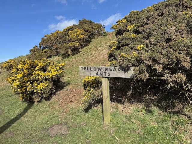
There were a great many small hillocks covered in gorse and a rather enigmatic sign reading YELLOW MEADOW ANTS. I thought it was referring to the gorse, and set to thinking how I might bring the phrase into conversation. Perhaps I could gaze from a train window and chuckle as I pointed out “yellow meadow ants” as we passed some flowering gorse.
We then started to notice what looked to be absolutely huge molehills. I began to worry that a mole large enough to produce these might emerge, knock me to the ground and steal my glasses. How fast can moles run? Audrey guessed what they were made by badgers and almost as soon as she said that we came to an information board telling us there were badger setts about. We didn’t see any badgers, though the following day we did, in a manner of speaking.
I went off on a bit of a collective noun tangent and wasted no end of time.
The collective noun for badgers? A Clan, Colony, Company or a Cete. A word I had not heard before. I wondered if it might be related to cetacean but that seemed odd. Cete was an alternative word for a whale in Middle English but the word cete used to describe a group of badgers actually has its origins in the same place as coitus. Their shared root had the sense of assembly or coming together. Cete came to mean group or clan and in modern English has given us set, as in a group. Set as in to “put in place” has a different origin that has given us sett as for a badger’s burrow. I’m uncertain which I prefer but it is either Colony or Company.
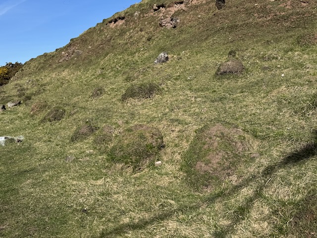
But… those large mounds were anthills made by…wait for it…yellow meadow ants, Lasius flavus. The mounds were about the height of a chair…
It is very tempting after a long walk to take rest on one of these comfy mounds, but be warned, if disturbed, a Yellow Meadow Ant can deliver a bite into which it expels formic acid from its abdomen, so we highly recommended that you avoid sitting on their hills!
We didn’t sit on the anthills; for fear of being bitten by a badger! Eventually we made do with a low grassy bank for our lunch break. It wasn’t ideal being on a bit of a slope and I kept slipping down. But we had a seat for lunch and I could watch orange bouys disappearing and bobbing up again—presumably lobster pots. No porpoises.
Once we were walking again, there were plenty of places we could have sat. too many to count. It makes you wonder if a malign spirit is having a good laugh.
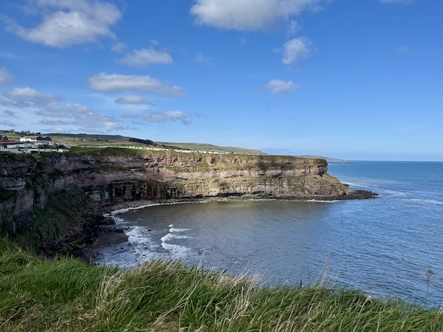
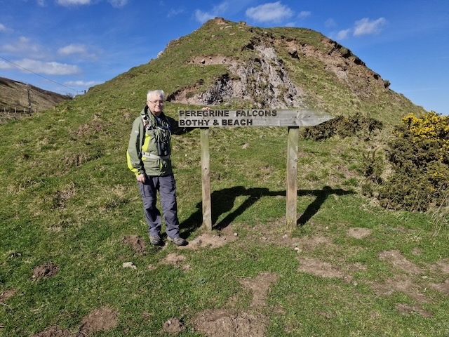
There were lots of rock formations to admire. And a sign pointing to PEREGRINE FALCONS BOTHY & BEACH. A roofless ruin sat on shelf below the cliffs, the remains of Lamberton Salmon Fishery. If that was the “bothy” it would be a bit on the rugged side for me.
There were some rather large violets that had us scratching our heads: sweet violets or heath violets perhaps. And English Scurvy grass, primroses and yet more celandine. Later we would come across fertile horsetails which neither of us recognised at the time.
We could see a number of small headlands ahead of us but could not tell which bay was Burnmouth and the end of our walk. I did see Maiden’s Rock so should have taken that as a marker but the farm buildings at Lamberton were the surest sign that Burnmouth was near.
The walls here were covered with what looked like beards, and there were even wild strawberries growing in crevices in the wall. The gully carved by the Catch-a-penny burn was filled with large blackthorn trees full of blossom.
I had been a little worried because the OS map shows the Coast Path heading straight down the steep cliffs at Cowdrait. I was hoping there would be steps. But I need not have worried; the path took a wide zig-zag so the descent was not particularly steep. I was particularly pleased because by then my toe, which had been grumbling for the last three days was beginning to chant its displeasure.
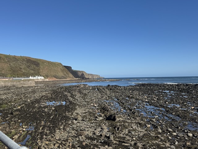
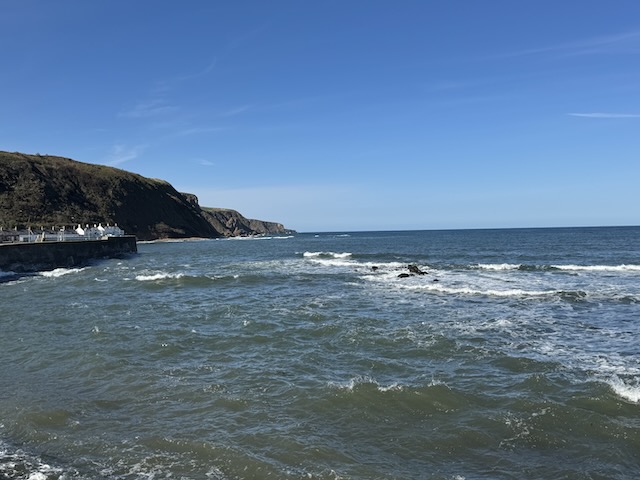
The tide had been out when we parked the car at Burnmouth revealing the rocks around the harbour. The sea had swept in since then and despite it being a calm day was throwing spray up above the sea wall. And there were folk swimming in the water at Cowdrait.
Burnmouth harbour has a small memorial for a disaster in 1881. Burnmouth lost 24 fishermen in a severe storm. In all 189 fishermen from the towns up and down the coast. The bronze memorial by Jill Watson shows a line of women and children looking out to sea for their lost fathers and husbands. They stand on a harbour wall which also looks like plaque or gravestone, blank but for the words “14th October 1881” carved at a bottom corner. I don’t know if the intention was to give this impression but I saw it as representing a gravestone, with the figures above it hoping it could remain blank.
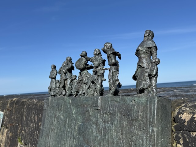
The memorial looked familiar but it is only when I was writing this that I remembered we had seen one very similar on the final day of our Southern Upland Way walk, near Cockburnspath.
I noticed a small boat shaped planter with Christina written on it, as we walked back to the car, but gave it little thought. Apparently it is one of five similar planters placed around the village: each is named after one of the Burnmouth fishing-boats lost in the storm of October 1881.
Download file for GPS