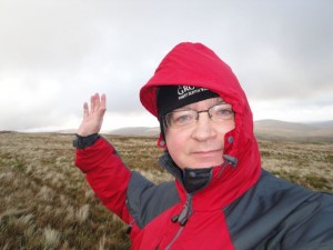
Here I am at 2012 feet in 2012.
Herman Law, Trowgrain Middle, Mid Rig, Andrewhinney Hill, Bell Craig, Mid Rig.
The Bodesbeck ridge runs SW-NE beside Moffat water. The NW face which looms over Moffat Water is steep, certainly too steep for me, whereas its SE side has several grassy fingers with gentler gradients, giving the appearance of a hand, albeit a little deformed. The ridge is a good choice for a short point to point walk, but since I was solo I had decided to start at the NE end and do a return (there and back) as far as Bell Craig. As it was I went one wee summit beyond Bell Craig.
Since this was the first walk of 2012 I had looked for any local hills of height 2012 feet, but since there were none, I headed for some just a little higher so I could at least get a photo when I was at 2012 feet.
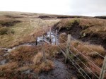
I parked alongside the road just a little way past Birkhill, over the county border in the Scottish Borders. There is a path visible snaking up to Trowgrain Middle from Birkhill and I planned to use that for descent but climb directly up Herman Law following the fence which marks the county border. I went through a gate to some sort of relay station with an aerial. I had presumed there would be a gate on the other side but was to be disappointed. Instead I climbed a wall and found myself between the wall and a barbed wire fence. This space I followed for a little while then climbed another wall to get onto the open hillside. At the end of the walk I noticed the public footpath sign near Birkhill which informs the observant of an easier way.
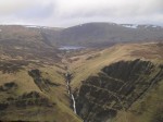
The route up Herman Law is steep but not exceptionally so. There were arrows on the fence pointing up the hill which seemed weird at the time but I can see now that the public footpath (not visible to the naked eye, but signposted) probably meets the fence here. Looking back over Birkhill, on the opposite side of the valley is a waterfall, Dob’s Lin. The hills across the valley have slopes which are very steep but despite this there were plantations of trees adhering to them. These must be wild growth, because I can’t see how the forestry could get up there to plant them. Unfortunately the cloud was low so there wasn’t much else to see. As I climbed Herman Law I pondered whether St Mary’s Loch might be visible from the summit. Standing at the summit, however, did not resolve these ponderings, since the visibility was poor except looking towards the Ettrick Hills.
I had hoped to get a photo of myself at 2012 feet on the way up so I kept checking exactly where I was with the GPS, but I walked past it. Rather than walk back down I decided to get the photos at the next 2012 feet, just a little way further on. The wind was pretty strong and I was unable to get the camera to lie still enough for the automatic shutter. The 2012 (feet) photos are therefore handheld self portraits in the biting wind.
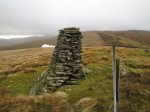
The route followed a fence so navigation at least was a no brainer. There is a collection of peat hags, languishing like hippopotamus in thick mud, in the col leading to the next hill, Trowgrain Middle. This hill has a cairn which leans, though not as impressively as the tower of Pisa admittedly. There are also numerous flat stones sticking out of the ground all around here which would be a major tripping risk in poor visibility. These presumably reflect a rocky layer that has been folded up but why they are so prominent here is a mystery to me.
Trowgrains’s name has a Norse origin. A grain is a branch, and several streams hereabout carry the name: East Grain, Black Grain. A trow is a trough, so Trowgrain is a branch in a trough. Looking from the south, Back Burn produces a trough in the hill and the hill between its two branches is Trowgrain Middle.
After Trowgrain there is another col with wallowing hags. The way through the mud is aided by bundles of rusting wire cast here and there that can be used as stepping stones, but sometimes a short diversion is the only way to avoid a mud bath. It is then a brief climb to Mid Rig, the first of two Mid Rigs on the ridge. If that isn’t confusing enough there are also two adjacent Mid Hills. From here the Moffat hills and Grey Mare’s tail should have been visible but were shrouded in cloud. The cloud would occasionally clear but never for long enough to get the camera fired up. It was so cold that the water from my bottle was painful to drink so I had to keep the camera inside my clothes when not in use since it gets sluggish in the cold. And I thought silicon chips worked better when cool. In contrast the Ettrick hills were bathed in sunlight.
Andrewhinney Hill at 677m is the highest point on the ridge, so it seems unfair that the ridge is referred to as the Bodesbeck ridge. I would be really interested to know where the name comes from but haven’t been able to find out. Was there an Andrew Hinney or is it an anglicisation of another name? This hill should have provided the best views of White Coomb, Loch Skeen and Grey Mare’s Tail, but they remained shrouded in mist, just occasionally allowing tantalising glimpses.
Heading down Scawd Law towards Bell Craig, I emerged from the cloud and had some better views of Loch Skeen. By the second Mid Rig it was time to head back since I had been going for two and a half hours and sunset was just over three hours away. I walked over to the cairn which is about a hundred metres from the summit in the hope it would offer some protection from the wind while I had a bite to eat. It didn’t. Whichever side I sat on was just as blowy. So I headed down towards the col and leaned against the fence while I had my coffee and Christmas Cake, with banana for dessert. I had had the foresight to wrap the vacuum flask in a spare woolly hat so it had remained warm.
This ridge walk had been quite tiring and I was tempted to head on to Bodesbeck, possibly contouring rather climbing it and then walking back to the car along the road. It would be further but much easier going underfoot with less re-ascent. My quick assessment was that this would be an additional 6 miles and from my previous experience of Bodesbeck I doubted the terrain would be amenable to shortcuts. So I decided to head back the way I came. It wasn’t quite as bad as I had thought, the wind was mostly helping me along on the return trip. Once on Bell Craig I looked up to Andrewhinney Hill and decided contouring would save some effort as well as giving better views of the Grey Mare’s Tail. The mist had cleared somewhat by now.
The contouring plan worked well, there were sheep tracks to follow at times and the ground wasn’t too steep or boggy. Unfortunately Strang Cleuch was filled with snow and I didn’t fancy walking across this and risking a slip so I abandoned my 610m contour and headed back up to the ridge and over Mid Rig.
My plan from here was to walk down to col before Trowgrain Middle then contour round until I found the path to Birkhill. There is a cairn marked on the OS map and I presumed that it would mark the path. Once in the col, however, the plan changed. I looked up at Trowgrain Middle and its cairn. It looked as though the summit was a little way from the cairn, so I went back up to check.
Standing at the cairn it certainly looked as if there was an area about 100m away that was higher. As I walked towards it, I felt I was going uphill. Once there I turned around and looked back. The cairn now seemed higher than me. Weird. I’ve checked the coordinates for the summit on the web and it seems the cairn is the top.
So I set off heading NW looking for the cairn. I didn’t see it even though my GPS route has me passing right by it. There was a blue plastic feed bin but I can’t think that is the cairn. The gradient gradually steepened and at last the path appeared.
Now from below this looks like a path, and I am sure it is. But it is quite eroded and is covered in mobile stones giving it the consistency of scree. Those who have seen me descending such paths (recall Skiddaw) will know that I left the queue when confidence was being doled out so this was slow. The only saving grace was that there was no one else there to experience my pathetically slow descent. It would be a great path for ascent or even for descent when dry.
As I walked back to the car I sighed as I saw the sign for the public footpath.
.


