 The sassenachs were fed freshly caught haggis and shortbread by the Wylies at the pre-walk team meeting. Then from what I can gather were tortured by electronic beeping to prevent a good night’s sleep.
An early morning start, 4.30am for me, 5am for lady wife. Porridge and toast respectively, coffee, then off to pick up Jim. I noticed Bailey prancing about in the drive but didn’t think to mention it since I presumed the dog stayed outside. Sorry Jim.
Completely out of character the Wylie car was at the Lochthorn rendezvous before us. Then off to Moffat for the team medical kit and Joanna (albino version).
At Tibbie Shiels we put on our kit and readied bladders. This year we were tagged for the walk and given yellow bracelets for our evening meal. Then we had some hanging about for the safety brief and morale boosting speech.
A bit of a slow start for several reasons. Queuing for the electronic tags to be scanned then along the South bank of St Mary’s Loch which in parts is single file. Some rain started to fall and stopping to put on waterproofs also slowed us a little, much more time queuing at the stiles to cross over towards Dryhope. Why couldn’t we use the gate?
The first rest stop was at Blackhouse with its ruins. Here we met the cosmopolitan oranges. I had some apple that had soaked up orange juice and must try that again. The grey skies gradually cleared as we walked on. Enough for me to regret not bringing the reactolites. I had gone for the “carry as little as possible” approach.
Walking towards the Bronze finish at Traquair we could hear the bagpipes. Change of socks, sandwich and drinks then ready for the next stage. The rain started and I felt obliged to recommend waterproofs for the team only to find the rain stopped in under five minutes.
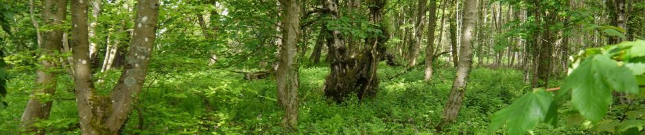
I find the walk up Minch Moor the hardest part of the walk and did lag behind the group on the way up. But in my defence I did stop to take off my coat and therefore lost the impetus of being with the team. The photo above was taken at the top of Minchmoor Road at the point of resolution, the natural sculpture of ovals that look circular from that vantage point. It was not much further along, near the Cheese Well, that the Eildon Hills first came into view. I don’t remember seeing them last year and they are not easily missed so the visibility must have been better.
Over Little Minch Moor on the path to Hare Law I was confronted by a man who first congratulated me for getting so far then asked if I had passed urine since starting the walk. This was one of those occasions when the brain interprets the input and decides it must have misheard, but no, that was what he asked. Luckily I was not anuric. More cosmopolitan oranges and some high5 drink to keep us going. By now the clouds were receding and our shadows were clearly seen.
The walk over Brown Knowe and Broomy Law was easy going on good paths with excellent views and the Eildons getting closer. The Three Brethren came into view from Brown Knowe and did look to be far distant, but came gradually closer. The path up does look steep but once we got to it, it did not seem as bad. In fact by this time I had already realised that age is catching up with my knees and I prefer slight inclines to downhill sections. Poor Graeme was hoping for a portaloo at the top but was to be disappointed. We were told that there were just ten miles to go to the end and two to the silver finish, the latter all downhill. The stop allowed Joanna to tend Bobbi’s blisters, and the rest of the team to have a well earned rest.
Comparing our times to last year using the time stamps on last years photos I think we were 15 minutes slower between the start and Three Brethren and 25 minutes slower between the brethren and the end, possibly due to a longer stop at Yair Bridge. I didn’t feel we were dragging our feet and if anything I would have stopped longer at view points to take in the view. Who cares? We completed the challenge.
The Brethren to Yair Bridge took us down some paths steep enough to hurt toes and gave me pain at the medial joint lines of both knees. I think I’ll change my mind and call this the most unpleasant part of the walk. Pretty soon we were in Yair Forest on flatter paths and soon walking along the banks of the River Tweed towards Yair Bridge where we were met by the pipers again. It was a great idea to have pipers at the stops.
A well deserved rest at the silver stop (with portaloos), bathed in sunlight. Change of socks, more food, a little banter and rehydration.
Then the slog up Hog Hill and the Eildons are back in view. As we come over the hill Gala is there beneath us, another welcome water and orange stop. Just 5 miles left to go, and I think we were all feeling the miles in our legs and feet. Then along the banks of the Tweed. I was pleased to see that the cycle path still has its “Melrose 2¼ miles” signs ten minutes apart.
The final stretch along the Tweed brought a lift in spirits, but when Elaine and Andy decided to speed up to overtake walkers in front of us I didn’t have a sprint finish left in me. Jim, Joanna and I continued at our usual pace.
It was a great feeling to cross the finish line, and see the rest of the team finish. Everyone was smiling as they did, which must be a good sign.
The post walk party saw David tricking all and sundry with his magic pipe. Plentiful food, drink and dancing.
I hope I’ve remembered everything. Well done David, Elaine, Joanna, Andy, Jim, Bobbi, Gary, Topsy, and Verity.


