Cluden Water and Nith Riverbank walk, Lincluden Abbey, Twelve Apostles and a lowly Trig Pillar
A beautiful crisp cold day with blue skies. I thought it would be appropriate to start this walk somewhere historic so I walked into town, passing the McGowan Memorial Fountain, and crossed the Auld Brig (Devorgilla Bridge). The original bridge here was built in 1260 by Lady Devorgilla, the stone bridge replacing it two centuries later. On the riverbank is a life-size relief of Devorgilla of Galloway, one of the most powerful women of the age, and 4great-grand-daughter of William the Conqueror.
I then turned left and headed under Buccleuch Bridge (originally called the New Bridge, built in 1793) and onto the Greensands. Just as there is now none of the white sand that gave the Whitesands its name, the Greensands shows no clue as the derivation of its name, but a little further along the route there is some actual greensand.
The Loreburn Bridge, built in 2001, carries National Cycleway Network route 7, and across this foot and cycle bridge is one of the Andrew Rowe designed cycleway mileposts. I then walked along the bank of the Nith opposite Nunholm. There is a very small caged footbridge across an unnamed burn even though the burn is narrow enough to easily step across. Here the Nith has another footbridge, the Academy Bridge, which was padlocked shut. The Stakeford weir would have been somewhere around here in ancient times and been a place to ford the river. The river bank beyond here shows signs of marked erosion, and there are areas of sand with grass growing through them. I presume the Greensands was once made of similar material.
The view from these fields is surprisingly good with Criffel, See Morris Hill and its neighbours, Queensberry, the Glasgow Road footbridge and the spires of the town all visible. The next crossing of the Nith is the Queen of the South Viaduct, which on this leg of the route I passed under. This 170m bridge was built as the Nith Viaduct in 1859 and carried the Port Railway to Stranraer. The railway closed in 1965 but the bridge survived and was revamped, renamed and reopened in 2008 as part of the national cycleway. Beyond the viaduct is a pathway alongside the factory which has an unfortunate amount of litter. The trees here look as if they have been coppiced, but I’m no backwoodsman and they may just grow like this. Unfortunately the A75 blocked my way along the riverbank but there are steps up to the road where I used the Green Cross code then took the steps back down to the river bank. The road wasn’t too busy this early in the morning but I would recommend those following in my tracks to make a short detour and cross the A75 by the footbridge.
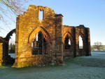
Lincluden Abbey is soon visible, standing close to the meeting of Cluden Water and the River Nith. There is a motte next to the abbey which would once perhaps have held a fortification but now has a grove of trees. The climb up was a little steep what with the slippy leaves. There is a gentler route up from the far side of the gardens but I only saw this once I’d slipped my way up the direct route. The best views of the ruins are from the mound but my mistake had been to set off too early, so the sun was still a little low for good photos. Another place for the revisit list.
Burns captures the atmosphere better than me, not surprisingly.
As I stood by yon roofless tower,
Where the wa’-flower scents the dewy air,
Where th’ howlet mourns in her ivy bower
And tells the midnight moon her care;The winds were laid, the air was still,
The Stars they shot along the sky;
The fox was howling on the hill,
And the distant echoing glens reply.
The Priory was established in 1160 by Uchtred, Lord of Galloway but in the 14th century the nuns of the priory were dismissed by Archibald the Grim, (Archibald the Black, Lord of Galloway, Earl of Douglas, scourge of the English etc). The nuns were said to have broken their vows of chastity, but bear in mind that the Earl sat in judgement on the matter and stood to gain much from the priory’s estates. In 1389, with papal backing (or perhaps pressure), he ordered a new church built and established a College of Canons to pray for his soul and those of his immediate family.
From the Abbey I headed back to the riverbank, this time of Cluden Water. The undergrowth here was quite thick in places but easily overcome. There is what looks like a small sewage treatment facility adjacent to the river, but in the freezing weather I was spared the smell. Glancing in I noticed that they had lifebouys, so those tanks must be deeper than they look.
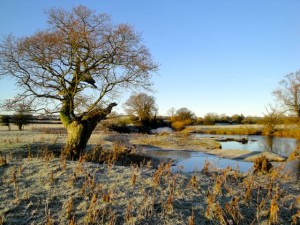
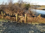
The Cluden itself is a pretty river (see the picture above), and though there was no sign of Mole, Ratty or Toad, there were plenty of ducks, geese, some rabbits and even a heron. The OS map shows a path along the Cluden, but it is more in the mind than on the ground; perhaps it’s just a right of way. There were well maintained stiles on the farmland but at the old ford near Hardlawbank, the stiles are overgrown and festooned in barbed wire, requiring a bit of a diversion. Further along the bank there are some houses whose gardens I suspect contain the right of way but it seemed impolite to climb into their gardens. As it was I found myself edging along a rather narrow steep overgrown muddy area between the gardens and the water. It would probably be better to take to the adjacent road and rejoin the riverbank 100m further on, especially if it has been raining or the river is high. The section between said cottages and Newbridge has a good stile over the fence (thank you, farmer). Across the river is a large house that I presume is Dalawoodie House. Once I had crossed the A76 I was in Newbridge, where I joined what once was the old route of Glasgow road and crossed the new bridge (built 1759).
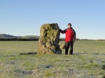
I then turned left and headed up to the field containing the Twelve Apostles. This is the largest stone circle in Scotland with a diameter of 89 m. There are eleven stones, but prior to 1837 there had been twelve. Local folklore says Judas has been removed. Historians think there were originally eighteen stones. Early writings, from the medieval period, refer to this as the Druid’s Temple, and a nearby village was even named Druidsville, but the Stone circle dates from 1500-3000 BCE, so it predates the Druids by a millenium. From the Druid’s Temple I followed the road to Holywood village where a couple of Christmas trees stood before the Church Hall. The holy wood has long since gone but was a forest of oak stretching for 6 miles north of here. This iteration of Holywood village is relatively new having developed after WW2; the original village (Druidville) had been a mile or so north, where the petrol station is now.
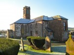
An Abbey was established at Holywood in 1121 and housed white canons (Augustinians) who included Joannes de Sacrobosco (John of Holywood), author of an influential book on ptolemeic astronomy, which was required reading in western universities for over four centuries. The abbey fell into disrepair following the reformation and was dismantled in 1778. The present church, constructed using stone from abbey, stands on the site of the old abbey, of which no visible signs remain.
The Holywood War Memorial is in the church grounds. It is inscribed 1914-1919. Many memorials carry these dates for WW1, reflecting the official conclusion of the war with the Treaty of Versailles on 28th June 1919, rather than the cessation of fighting with the armistice in 1918. From the rear the church bears a striking resemblance to the haunted church in the Mad Monster’s Mansion level of Banjo-Kazooie (ah, the heady days of N64). Behind the church runs a line of trees along the dismantled Cairn Valley railway branch line. I had originally planned to use the old railway line as part of the route but it is quite overgrown and would only be useful if one wished to recreate the experience of passing through dense jungle. I had not brought a machete, so walked on the road instead. I must be a towny at heart.
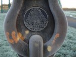
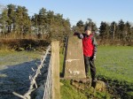
A little past Holywood church is a trig Pillar in a field of docile sheep. I had not seen one in open countryside before. It stands at the impressive elevation of 27m and is the lowest in the county, if you ignore those on the coast. This was the half way point. I then headed south along a single track road trying to place my feet where the sun had melted the ice and squinting into the sun. I was now walking in the tongue of land lying between the waters of the Nith and the Cluden, towards the site of the old Martinton ford. Since all was flat around me there were good views of Criffel to the south, See Morris Hill and friends, and the hills beyond Amisfield.
Rather than continue along the track directly to Nunholm, I took a left through a concrete ginnel under the railway. This had a pool of frozen slurry filling it. Did I say frozen? Not once I was in the middle of it when the surface gave way. Luckily it was only a couple of inches deep but enough to coat my boots. To cap it all the outside tap was frozen when I got home as well. From here it was across open pasture with huge flocks of geese circling above me until I fought my way through fence and hedgerow to get onto and across the A75 near the A701 junction. The road was busier now and the crossing took some time. I suspect it would have been possible to pass under the bridge on the river bank which would have been easier and safer. The reason for this detour was so I could walk along the riverside levee that I have seen so often when driving along the ring road. Well I’ve done it now and that’s all I can say about it. If I did this route again I would either miss this section out or cross the Nith on the pavement of the road bridge and walk along the other bank, which has a path.
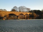
Once along the levee I passed under the Martinton Bridge, carrying the railway. This dates from 1849 and I presume is close to the ford so loved by Burns. There was then a short tramp through some more overgrown undergrowth and a climb back up to the ring road, to cross the Nith on the road bridge to bring me back down to where I would have been, had I not chosen the slurry filled ginnel.
I was now in Nunholm, a name which reflects this was the route to the “Islet (holm) of the Nuns” at Lincluden Abbey. This route would have crossed the Nith at the (now lost) ford whereas I used a road bridge. From Nunholm, the cycleway with its bicycle statue crosses the Nith on the Queen of the South Viaduct and heads west then south passing, as the railway once had, under several bridges.
At Castle Douglas Road I turned back towards the town, pausing to look at the statue of Peter Pan and Tinkerbell, which I have to admit has yet to grow on me.
This was an interesting walk, with several antiquities to visit. Burns apparently enjoyed these areas. Allan Cunningham in The Works of Robert Burns (1834) says:
While he lived in Dumfries he had three favourite walks; on the Dock-green by the river-side; among the ruins of Lincluden College; and towards the Martingdon-ford, on the north side of the Nith. This latter place was secluded, commanded a view of the distant hills, and the romantic towers of Lincluden, and afforded soft greensward banks to rest upon, within sight and sound of the stream
.

